Data visualised in digital twins
Exclusively from ‘SAFE: A collection of works exploring a safer world’, this lamp translates real time data into a ‘digital twin’.
This page is approximately a 8 minute read
This page was published on

(Copyright: Atkins)
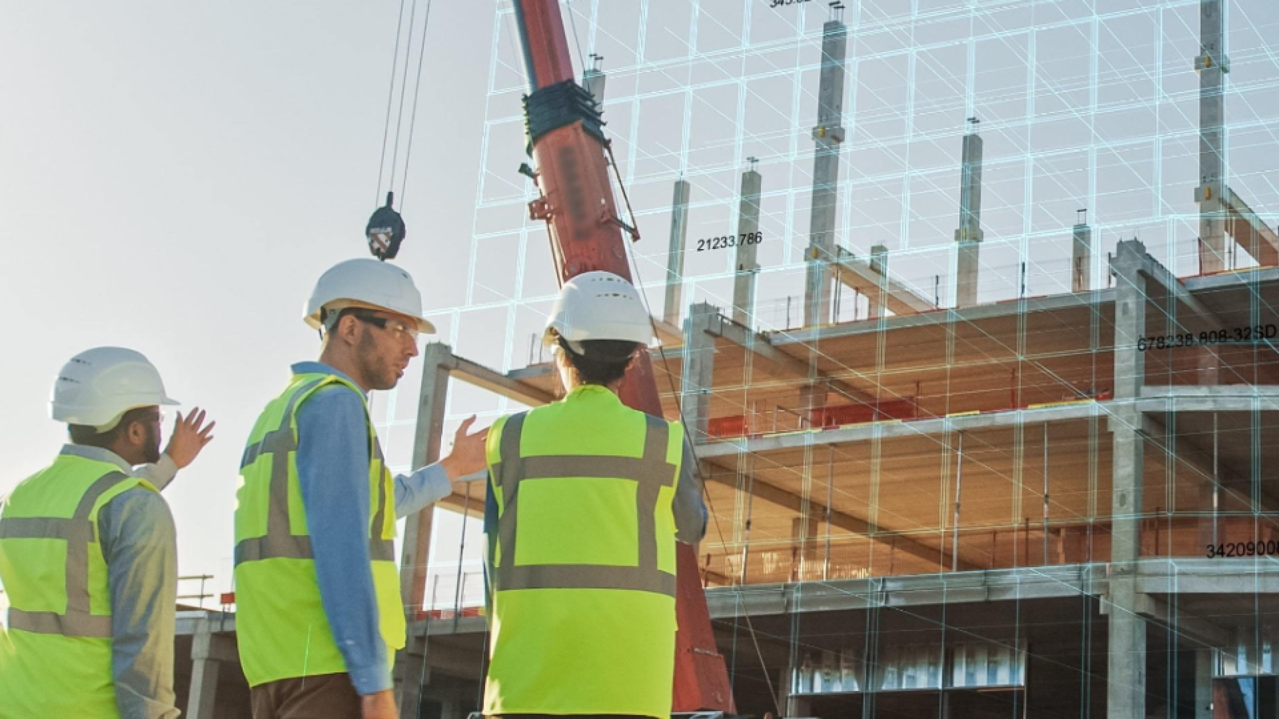
Currently, there are over 1.1 million households in England on the social housing waiting list, even though in England there is enough brownfield land to build an estimated 1 million homes. One of the biggest blockers in developing these sites are unknown ground conditions, especially where there is the potential for contaminated land to pose a health risk.
This discovery research project led by engineering and design consultancy company Atkins aimed to identify how well currently open datasets can support developing insights into contamination of brownfield sites, and comparing that approach with existing commercial and unused datasets.
Even though we know that the ground conditions on brownfield sites can have a big impact on health and safety, the levels of contamination within the ground are not yet being recorded or made available in the same systematic way. For example, often these datasets are under commercial terms, which may make it harder for some to access.
Repeated surveys of the same ground by different developers are a typical example of this problem. A combination of data being held on a project by project basis, a lack of visibility of data acquired and difficulty gaining access for reuse mean that developers spend time and money repeating data collection activities.
The creation of data for specific projects or surveys being used once and never again is a challenge faced across many working on the built environment. The number of initiatives in place looking at different models for sharing data indicate the scale of the challenge and the potential value to gain.
The team interrogated their internal database to identify data from relevant past projects. The search included 1500 projects from the public and private sector and highlighted the range of organisations holding data on this subject.
Focusing on two use cases, the team examined the data available to understand contaminants in land, and identify gaps at site-specific and national levels.
Initial discussions have begun with key-stakeholders in this sector including AGS, Geospatial Commission and Bentley and should support the delivery of the ambitions in the UK Geospatial Data Strategy. If organisations within the sector are able to align on the way they will access, use and share data this could make things much more streamlined, improving efficiency and reducing costs on projects. The network effects of this could be widely felt.
"This project highlights the opportunity for industry to collaborate to unlock the power of location data about brownfield land contaminants."
A third of construction practitioners (approximately 1 million people) do not have easy access to all the knowledge they need to do their job. The number one barrier to accessing knowledge is not being aware of what knowledge is available. There is a need for quick and straightforward access to knowledge on demand.
Barbal, a Bristol based SME specialising in creating open standards for data, worked with the Construction Knowledge Task Group to create a shared way of publishing construction knowledge, so that it becomes discoverable. In time, this will greatly improve practitioners’ access to the knowledge they need to safely perform their role and implement a safer built environment during construction and in-use.
Tom Bartley, who led the project says: ‘This is a great example of cross-industry collaboration. The standard prescribes a simple change that will make a huge difference to the entire industry. The power is in finding common ground where it is important and allowing freedom where appropriate. The schema can be adopted by organisations publishing openly or internally to provide a single way of describing knowledge from a range of sources.’
Working in close collaboration with key stakeholders in the construction industry, and building on existing work of the Construction Knowledge Task Group (CKTG), Barbal – an SME specialising in open standards – focussed on achieving a consensus based approach to making construction knowledge more discoverable.
Over 6 months the team engaged stakeholders via a series of workshops, interviews and a survey to define what success looks like, understand user and publisher experiences and develop a standard way of publishing construction knowledge and datasets so that they are discoverable.
The team recognised three main requirements for the standard for publishing. The output needed to ensure:
To further engage the community, the team openly published all meeting notes, background documents and outputs using creative commons licensing in an open-source repository throughout the project.
Through this project, Barbal have demonstrated that taking an open and collaborative approach accelerates the development of technical solutions that traditionally take years. The ODI's manifesto recommends that standards bodies work with the engineering sector to support the development and adoption of data and metadata standards that support the sharing and use of data. The implementation of a standard can take time, but when the standard is open, as in this case, and adoption is supported, there is potential to save industry time and money.
Air pollution is one of the leading contributors to increased mortality around the world, with established links to numerous heart and respiratory diseases. Roughly 7 million deaths a year are rooted in air pollution and more than 80% of people who are affected by poor air quality live in urban areas, such as cities. City decision-makers must do more to mitigate poor air quality and protect citizens, by making better decisions around city planning.
Areas around Leeds have the worst air pollution outside of London. Changes need to be made to improve air quality in and around the city, but the consequences of planning decisions on air pollution are not currently well understood.
City decision makers need to be able to make decisions about city planning, without fearing that those decisions will have a negative impact on citizens, or the wider city ecosystem. To do this, they need access to information about how different scenarios might unfold, and what the consequences of those scenarios might be.
Understanding how our cities are operating in real time can play an important role in helping us to solve some of society’s biggest challenges. The ‘Breathing City’ project – an initiative led by Slingshot Simulations – aims to demonstrate how open data can be used to create a digital representation of a city, which can provide valuable insights about the impact of pollution, and help decision-makers to improve the wellbeing and safety of city populations.
The ‘Breathing City’ project is demonstrating how the use of open data can create a digital version of a city, i.e. a digital twin, to improve the wellbeing and safety of urban populations and provide valuable insights to educate society on the impact of pollution.
Slingshot Simulations has created a digital twin of Leeds city centre, using multiple open data sources, which can be used to understand the challenges faced around air pollution in the city.
The digital twin enables city decision makers to simulate different scenarios in which changes to city infrastructure could have a significant impact on the effects of air pollution.
The digital twin has the potential to be rolled out across different cities, with a reusable simulation being produced as part of the project. Newcastle-under-Lyme council have approached the team to explore replicating this in Staffordshire.
The project has provided Slingshot with an opportunity to produce a working digital twin of a major UK city, which helps to address a city priority around the reduction of the harmful effects of air pollution. Throughout the project, the Slingshot team has made new connections with local community groups, businesses and national bodies, such as the Centre for Digital Built Britain and the Digital Twin Consortium, which convene around the digital twin agenda.
Slingshot’s work has created a foundation for helping to city planners in a COVID-19 world, which will be further explored through their new follow-on project – A Living Model for People and Place – which is funded by Innovate UK and supported by the University of Leeds VirtuoCity Centre for City Simulation, Leeds City Council and Newcastle-under-Lyme Borough Council.
Exclusively from ‘SAFE: A collection of works exploring a safer world’, this lamp translates real time data into a ‘digital twin’.
In this article, Dr Darshana Godaliyadde, Director for the Resilience4Ports initiative, discusses how the programme is empowering global ports to adapt, securing not only trade but also local employment, food security, and community well-being.
Discovering Safety joins forces with Safetytech Accelerator to build a Smarter Regulation Sandbox.